

Phnom Bokor
Phnom Bokor is about 12 kilometers west o Kampot provincial town. The mountain was discovered by a group of foreigners in 1917 and later organized by a Frenchman named Roulouse on April 13, 1922, during the reign of the King Sisowath. During colonial times, Phnom Boker was a place of the coastal plain.
The mountain is 1,075 meters high and the temperature at the top is often quite cool. Because the road is poor, the 30 meters trip from the base to the top of the mountain can take up to two hours and sometime longer, depending on the mode of transportation. Those who make the trip, however, will find a lust forest, large rocks shaped like animals and sailing junks, as well as a spectacular panoramic view of the Kampot Countryside, of Sihanoukville and of the bright, blue sea.
During then-Prince Norodom Sihanouk’s SangKum Reastr Niyum regime became a small town, Borei Bokor. Today, most of those buildings are dilapidated and no longer in use. The mountain also features a three-stage waterfall and a Popok Vil1, which are about 7 kilometers from Borei Bokor.
Teuk Chhu
Teuk Chhu is located in Snomprampi village, Makprang commune, Kampot district, about 8 kilometers north of Kampot provincial town. Its main attraction is a stream that flows from Phnom Penh Damrei via Phnom Kamchay. The cool, clear water flows over large rocks year round. This is a good place for swimming or bathing.
There are many kinds of delicious fruit available, including durian, mangos teen, rambutan. Mak prang, pineapple, grapefruit, custard apple and coconut. Only the durian, however, is available year around. Not far from Teuk Chhu is a zoo and plantation organized by His Excellency Nhim Vanda. The zoo raises animals, while the plantation grows a variety of fruit trees, including durian, rambutan and other fruits.
Phnom Kampong Trach
Phnom Kampong Trach is located a South Damnak Kuntuot commune, Kampong Trach district, about 38 kilometers east of Kampot provincial town. It is a rocky mountain with few plants. The site includes a cave at the foot of the mountain, as well a number of small mountain wells that local people of Cambodian, Chinese and Vietnamese descent use for worship.
One of mountain wells is 30 meters in diameter, and its soil is seven different colors. Several smaller wells have artistic stones that look like animals and other objects. From this large well, there is a cave way to Viel Sre Muoy Roy and Thma Dos wells, which were used by filmmakers in the 1970s.
There are a Chinese-Vietnamese pagoda at the foot of the mountain, and a Khmer pagoda in front of the Entrance to the cave. The monk at the pagoda and the monastery committee are working together to preserve the cave.
Prek Ampil
Prek Ampil is located on the coast in Koh Toch commune, Kampot district, about 18 kilometers west of the provincial town. Prek Ampil feature a white sand beach with thousands of mangrove and coconut trees growing nearby, ,making the site ideal for visitors looking for a pleasant place to relax. In addition, there is an array of fresh seafood such as crab, cuttlefish, lobster and snails, as well abundant coconut juice. The waters off of Prek Ampi are rich in corals, a natural attraction that could attract tourists who enjoy snorkeling or scuba diving.
With the exception of Teuk Chhu, one of the sites listed above have been developed for tourism, although efforts have been made to stop further destruction at the sites. To-day, locals and some foreigners visit the sites to do research.
Handicrafts
Most of the handicrafts made sea shells and corals that are popular with tourists are made in Kampot province.
– Shell Handicraft
This handicraft is sold along the beaches and is very popular with tourists.
– Corals
Corals are also popular with visitors. The coral is washed until it is white, and sold along the beach to local and foreign visitors. Because coral is rapidly disappearing from the sea and oceans, however, environmentalists discourage tourists from buying these souvenirs.
– Salt Products
Salt Products are among the items Cambodia produces for export. Cambodian can produce enough salt or use inside the country also for export. Most of the products are made Kampot District nearby the sea.
Kep, Kep Beach
Kep is a seaside tourist city located 173 kilometers southwest of Phnom Penh. Visitors from Phnom Penh take the National Road 3 via Kampot Province or National Road 2 via Takoa Province. In addition, the train form Phnom Penh to Sihanoukville stops at the Damnak Canng Eur Station, about 7 kilometers from the city, foreigners coming from Vietname or Sihanoukville to the Kep City Port.
Kep is a small city. The beach, which is suitable for swimming, is only 1,000 meters long, and the sand is not white as in Sihanoukville. However, Kep is a big seafood market.
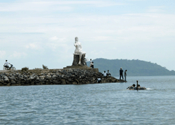
The city was founded in 1908 during the friend colonial times. It was renovate into a beautiful seaside resort in 1960s during the King Norodom Sihanouk’s Sangkum Reastr Niyum regime. The name Kep is derived from the French words Le cap, or cape in English. A cape a point of land juts into water, especially a headland significant for navigation.
Khmer legend offers another explanation for the name. there once was a prince name Sakor Reach who possessed great magical powers. One day, Sakor Reach used his magic to hypnotize a commander of Angkor Thom before stealing the commander’s horse and escaping to the south west part of the country. While Sakor Reach was relaxed the seaside, the commander’s troops caught up him. Nervous, the prince suddenly hopped on the back of the commander’s horse. The horse reared back, however, and fell on the prince, losing its saddle1 in the process. The prince got back on the horse and rode off, leaving the saddle there. Hence, the area was called Kep She. Later it was shortened to Kep.
Phnom Sar Sear
Phnom Sar Sear is a nature and cultural site located about 14 kilometers southeast of Kep city. This mountain is called Phnom Sar Sear because, according to Khmer legend mentioned above, when Price Sakor Reach led the troops to this place, he got off his horse and moved furtively2 ahead of his pursuers along the mountainside, where at that time there was an island to which he led. Thus , the mountain was called Phnom Sar Sear.
Phnom Sar Sear is composed of three small mountains about 1,5 square kilometers. It is about 40 meters high. The site feature two natural caves–Phnom Dorei Sar and Phnom Ach Prochiev–which tourists can explore. In Phnom Domrei Sar cave, there is a beautiful mountain well called Viel Sre Muoy Roy. In the past, this site was also popular with filmmakers.
At the foot of the mountain are a number of small of small halls where clergymen and nuns meditate. Along the way to the mountaintop, there is a Buddhist pagoda where monks live. On the mountain sites a colorful, finely sculpted stupa built in 1964 by Prince Rasmei Sophoan. A place of worship, it also house a Buddha relic.
The fresh air and beautiful natural scenery make Phnom Penh Sar Sear popular with tourists throughout the year. From the mountain top, visitors have an excellent view of the rice paddies, the islands and the sea below, as well as the distant mountains. Buddhists go there to prey for good fortune.
Koh Tonsay
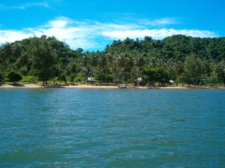
Koh Tonsay is located about 4,5 kilometers southeast of Kep. Tourists are drawn to the beautiful white sand beaches. The sea here is shallow and has a long slope, making Koh Tonsay excellent for swimming. At the sea bottom are a variety of carals, sea animals and plants which attract researchers and ecologists.
The name Koh Tonsay is derived from the word Rumsay3 While trying to avoid the commanders troops, Prince Sakor Reach grew hopeless because his own troops began to tire. He led his remaining troops across the sea to an island in front of Kep city, where the troops spread out. Accordingly, the island was called Koh Tonsay, as it is known today.
Koh Tonsay is 2 square kilometers. During then-Prince Norodom Sihanouk’s Sangkum Reastr Niyum regime, it was used as a place to rehabilitate criminals, who were also used to defend the island. Horse cart paths and wooden, thatch-roofed motels were also constructed during this time. Most of this infrastructure has been destroyed by weather and decades of war. Today, seven families lives on the island they earn their living by fishing and growing coconut trees.
